The Puzzle of Thermopylae
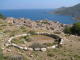
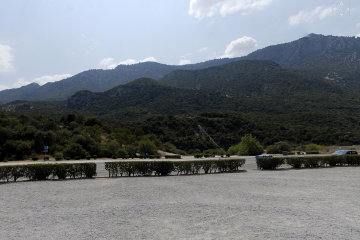
| Thermopylae | 38 47 47.22N 22 32 11.43E | See the accompanying article for details of what is visible in the picture. |
| |
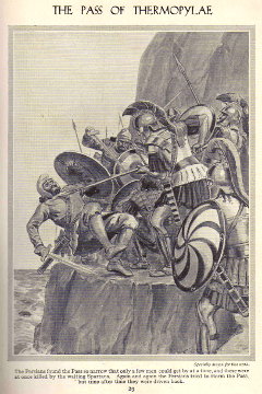
| The Battle of Thermopylae according to Newnes' Pictorial Knowledge. They even managed to get the sea on the wrong side! |
When I was just a boy someone gave us a copy of Newnes' Pictorial Knowledge, a set of eight volumes, nicely bound in fake leather, which purported to encompass all the knowledge of the world. Each volume was divided into sections: there was a feature on world cultures with sepia photographs of such iconic structures as the Forth Bridge, the Taj Mahal and the Eiffel Tower. Another section dealt with the electricity and such up-to-date inventions as the Marconigram, arc lamps for cinemas and giant turbines powered by Niagara Falls. There was even a section on useful hobbies for boys (girls, as I recall, didn't get much attention) which included complete plans for making a balsa wood and tissue paper glider.
The section on world history featured the Battle of Marathon, the Battle of Themopylae, the assassination of Julius Caesar and then turned to British history, passing rapidly over the awful Vikings, the incompetant Anglo-Saxons, the vicious Normans, and the rise of the British Empire. (I seem to recall that Roland and Charlemagne were mentioned somewhere, but possibly they were in the section on world literature!)
The three page article on Thermopylae fired my imagination, for as well as the brief text there was also a full-page picture showing heroic Greeks in armour and crested helmets defending a narrow road by poking long spears into dismayed-looking Persians and pitchforking them forty or fifty feet down into the raging sea below. The Persians had no choice but to keep coming because on the other side of the road towering cliffs rose up into the sky. This was the obvious spot in which to defend Greece and Civilisation and, probably, Britishness.
It was, therefore, something of a shock to drive down the coast of Greece some years ago and discover that we were passing the little village of Thermopylae! On one side there were indeed steep-sided hills, but of cliffs there were no sign. On the other side a gentle slope spread out to a wide coastal plain. Leonidas and his brave three hundred and the Persian hosts could have passed each other in broad daylight without either becoming aware of the other!
Since then I have read numerous accounts of the Battle of Thermopylae and they are all agreed that the coastline has changed greatly since the days of Xerxes. The sea has retreated - or the land risen - with the result that what was once a narrow pass is now a broad plain. Unfortunately, even if you have the sea lapping against the very foot of the hills, it is still hard to accommodate the dramatic scene of Newne's Pictorial Knowledge. There is no ancient roadway cut in the hillside - and even if there were, the Persians pitched over the edge would simply roll a few feet down the gentle slope, then pick themselves up and return to the fray.
| |
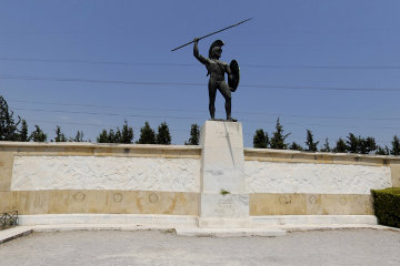
| Leonidas and power lines; the Greeks really are not the best guardians of their heritage! |
Still, the Greeks presumably knew what they were doing and Leonidas cannot have been altogether a fool. What is more, there is no possibility of mistaken identification because "thermo-pylae" means "hot gates" and there is indeed a hot spring only a short distance from the modern village of Thermopylae.
If you want to see the location for yourself you can, of course, join one of our tours next time we go to Greece. In the meantime, however, you may wish to use one of the excellent mapping programs, such as Google Earth, and enter the following coordinates.
| Thermopylae | 38 47 47.22N 22 32 11.43E |
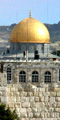
That should take you to the middle of the road opposite the Leonidas Memorial which stands on the site of the Battle of Thermopylae. It may surprise you to notice that the famous pass runs east-west, not north-south.
Zoom out a little bit and a short distance to the east you will notice a cluster of houses laid out on a rectangular grid. This is the modern village of Thermopylae, which need not concern us further other than to note that the River Dyras flows out of the mountains and down to the sea at this point.
In the other direction the road curves away from the green, forested slopes of the hills and crosses over a dry river bed. This is the River Asopus and if you fiddle around with Google Earth a bit and tilt the picture so as to give you a 3D view, you will see that the Asopus issues out of a rather dramatic gorge in the hills.
| |
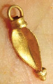
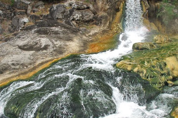
| The hot spring at Thermopylae. |
Just before the road crosses the Asopus there is, on the south, four red-roofed buildings surrounded by neatly laid out orchard and gardens and immediately south of this farm there is a small stream. This is the hot spring known in Greek times as the River Phoenix, which provides the "hot" in the "Hot Gates". If you are using Google Earth and you have the "Pictures" option ticked, you should find half a dozen pictures showing the spring and the steaming water running down the channel.
Before leaving Google Earth, once more tilt the picture and look at the mountains to the south. You might also search for other pictures showing the general area and note the wide coastal plain as well as the slopes of the mountains. It is said that the ancient sea shore was approximately where the modern road is today. I do not believe that.
Now that you have the lay of the land in your mind, let us look at the description given by Herodotus.
As for the entrance into Greece by Trachis, it is, at its narrowest point, about fifty feet wide. This however is not the place where the passage is most contracted; for it is still narrower a little above and a little below Thermopylae. At Alpini, which is lower down than that place, it is only wide enough for a single carriage; and up above, at the river Phoenix, near the town called Anthela, it is the same.
West of Thermopylae rises a lofty and precipitous hill, impossible to climb, which runs up into the chain of Oeta; while to the east the road is shut in by the sea and by marshes. In this place are the warm springs, which the natives call 'The Cauldrons'; and above them stands an altar sacred to Hercules. A wall had once been carried across the opening; and in this there had of old times been a gateway.
These works were made by the Phocians, through fear of the Thessalians, at the time when the latter came from Thesprotia to establish themselves in the land of Aeolis, which they still occupy. As the Thessalians strove to reduce Phocis, the Phocians raised the wall to protect themselves, and likewise turned the hot springs upon the pass, that so the ground might be broken up by watercourses, using thus all possible means to hinder the Thessalians from invading their country. The old wall had been built in very remote times; and the greater part of it had gone to decay through age. Now however the Greeks resolved to repair its breaches, and here make their stand against the barbarian. At this point there is a village very nigh the road, Alpeni by name, from which the Greeks reckoned on getting corn for their troops.
| |
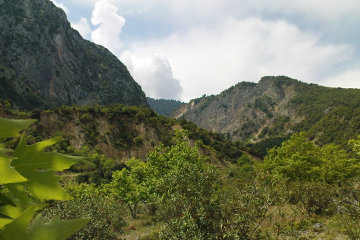
| The hills above the pass of Thermopylae, by no means unclimbable! |
The ancients were not hill-walkers or climbers and we may take Herodotus' assertion that the mountain was "impossible to climb" with an appropriate measure of salt. He is more in accord with the facts on the ground when he states that the roadway was only wide enough for a single carriage and that whatever natural advantages the site possessed had been improved by the works of man. Men had built a wall across the pass and had, furthermore, diverted the hot stream to make a number of watercourses which would hinder any invader. Given that the stream can be waded across without difficulty, dividing it into a number of streams would make it less of an obstacle rather than more.
A little further on Herodotus adds to his previous description:
South of Trachis there is a cleft in the mountain-range which shuts in the territory of Trachinia; and the river Asopus issuing from this cleft flows for a while along the foot of the hills. Further to the south, another river, called the Phoenix, which has no great body of water, flows from the same hills, and falls into the Asopus. Here is the narrowest place of all; for in this part there is only a causeway wide enough for a single carriage.
From the river Phoenix to Thermopylae is a distance of fifteen furlongs; and in this space is situate the village called Anthela, which the river Asopus passes ere it reaches the sea. The space about Anthela is of some width, and contains a temple of Amphictyonian Ceres, as well as the seats of the Amphictyonic deputies, and a temple of Amphictyon himself.
| |
| The gorge from which the River Asopus leaves the mountains. |
We have already noted the "cleft" or gorge from which the Asopus enters the plain and if we zoom out a little we can see how Herodotus' statement that the river "flows for a while along the foot of the hills" is absolutly correct. However if you zoom in again and trace the course of the hot stream, the Phoenix, you will see why the modern road cannot be the line of the sea. Herodotus tells us that the Phoenix flows into the Asopus and owing to the lie of the land, that happens north of the modern road and cannot ever have happened further south!
What is more, between the spot where the two rivers join and the sea there was an area of "some width" where the village Anthela stood, together with its temple. Even if we allow of a degree of exaggeration and conclude that the shore followed the course of the modern, two-lane expressway, we still have a third of a mile between the putative shoreline and the point where the hills begin. YOu can fit quite a few carriages into a third of a mile!
The solution to the problem, I believe, can be found in Pausanias' Guide to Greece, where he describes a later battle which took place at Thermopylae between the Greeks and the Gauls.
Cavalry was no use on either side because the Gates are a narrow pass and the ground is broken and slippery, a continuous series of streams among rocky outcrops. ... Meanwhile the Athenians on the warships with some difficulty and danger sailed in through the mud-banks that stretch far out to sea and held their ships close inshore, bombarding the flanks with all kinds of arrows and weapons. The Celts were indescribably tired and, being in a narrow place, they had little effect while they suffered two or three times as much, so their commanders gave them the signal to retreat to camp. As they turned away in broken ranks and no kind of order, many of them were trampled under each other's feet and many went into the swamp and disappeared in the mud; as many of them perished in the retreat as died in the height of battle.
Notice that the sea off Thermopylae is shallow, which accords with the modern dry land that extends far out into the gulf. More importantly, notice that the Gaulish attacks were hindered by a swamp deep enough for men to disappear in, a swamp which was crossed - so Herodotus tells us - by a causeway.
Here, then, is my reconstruction of the situation.
Faced with invasion by their Thessalian neighbours, the people of Phocis first built a wall across the narrowest part of the pass and then, in perfect accord with defensive structures of the time, they constructed a moat in front of it. There was the shallow valley of the Phoenix and there was the stream. As I have already indicated, the stream was not much of an barrier in its own right and it would be made even less of a hindrance if it were broken up into a number of smaller streams. But if it could be dammed in this shallow valley, then you really would have a significant obstacle!
| |
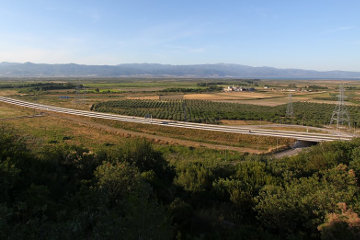
| The modern plain near Thermopylae. Some believe that the ancient shoreline was where the freeway runs. |
So the Phocians built a dam across the valley at the point just below where the two rivers meet. We need not think of a water-tight dam, merely of a dyke of rocks and gravel that would hinder the flow of the streams and cause the water to back up and fill the shallow valley. This pond would rapidly be overgrown by reeds and aquatic plants, further hindering the flow of the water and creating the large marsh which the Gauls found so deadly.
Even today there appears to be a small marshy area where the modern expressway impedes the flow of the combined rivers. It is not hard to imagine a bit of judicious engineering with the main dam and possibly other mud banks higher up, producing a swamp that filled the valley with pools of water and thick mud.
Describing the final day of fighting at Thermopylae, Herodotus states:
Many were thrust into the sea, and there perished; a still greater number were trampled to death by their own soldiers; no one heeded the dying. For the Greeks, reckless of their own safety and desperate, since they knew that, as the mountain had been crossed, their destruction was nigh at hand, exerted themselves with the most furious valour against the barbarians.
In view of the gentle slope into the sea, I would presume that any Persian pushed into the water would merely rise up, much refreshed, and return to the attack. However if this part of the struggle took place on the causeway, we may presume that the causeway had steep sides, possibly undercut on the seaward side by wave action, and at its highest may have been ten or twelve feet high. A Persian pushed over the edge here might indeed fall into the sea, hit his head on the rocks which made the base of the causeway, and lose all interest in further proceedings.
My reconstruction solves another mystery of Thermopylae: at Marathon the Greeks charged at the Persians without stopping to dress their line and the reason for this variation from normal battles was their fear of the Persian archers. That there were archers present with the Persians at Thermopylae we can gather from the story of the Spartan soldier who, when told that the Persian arrows were so numerous they would darken the sky, remarked laconically, "Ah, good. Then we shall fight in the shade."
So why did the Persian king persist in sending his men to the slaughter when he could simply have ordered his archers forward and exterminated the Greeks under a hail of arrows? The answer is that the swamp separating the two armies was sufficiently wide that the Greeks were beyond bow shot. While the marsh itself may not have been more than a bowshot wide, by moving a short distance back from it the Greeks could remain out of range while they waited their turn to join the fighting at the causeway.
© Kendall K. Down 2016